
Methane is invisible, odorless in its natural state, and highly potent as a greenhouse gas. For gas grid operators managing hundreds or thousands of kilometers of pipeline, even a small, slow leak can go unnoticed for months, accumulating risk, wasting gas, and creating regulatory exposure. That is why CH4 detection has moved from a routine maintenance task to a strategic priority. Early identification of leaks protects infrastructure, reduces emissions, and keeps operators on the right side of an increasingly demanding regulatory environment. This article explains what early methane leak detection means in practice, how airborne technology makes it possible, and why acting sooner rather than later pays off.
What is CH4 detection and why does it matter for gas grids?
CH4 detection refers to the process of identifying and locating methane emissions from gas infrastructure before they grow into larger, more dangerous, or more costly problems. Methane (CH4) is the primary component of natural gas, and any unintended release from a pipeline, valve, or fitting represents both a safety hazard and a direct financial loss for the operator.
For gas grid operators, detection matters on several levels at once. From a safety perspective, methane accumulations in confined spaces or near ignition sources can be explosive. From an environmental perspective, methane is a potent greenhouse gas with a global warming impact far greater than CO2 over a 20-year horizon. And from a regulatory perspective, the EU Methane Regulation 2024/1787 now places binding obligations on operators to survey their infrastructure using technologies that meet defined sensitivity thresholds.
The distinction the regulation draws between Type-1 and Type-2 inspections is particularly important. Type-1 inspections require a detection limit of 17 g/h, which is achievable with optical gas imaging cameras or handheld equipment. Type-2 inspections require a detection limit of 5 g/h (or 1,000 ppm local concentration), demanding considerably more sophisticated technology. Operators who invest in Type-2-capable systems are rewarded with longer inspection intervals, up to three years for underground pipelines, which directly offsets the higher cost of more sensitive equipment.
What are the risks of undetected methane leaks in pipelines?
When a methane leak goes undetected, the consequences compound over time. A slow seep that might have been repaired quickly and cheaply can widen into a more serious structural failure. Gas that escapes is gas that cannot be delivered or billed, creating a measurable commercial loss. And because methane is far more effective at trapping heat than CO2 over short time horizons, even small undetected leaks contribute meaningfully to an operator’s emissions footprint.
There is also a physical reality that makes underground leaks particularly tricky to find without the right tools. Research by METEC (Methane Emissions Technology Evaluation Center) and the Engler-Bunte Institute demonstrates that underground emissions do not simply vent directly above the leak point. Gas travels through the soil and the surface plume widens before emerging, meaning the visible concentration at ground level may appear some distance from the actual failure. This widening effect means that a detection approach covering only a narrow strip directly above the pipeline centerline will miss a significant proportion of real leaks.
The regulatory risk is equally real. Under Article 14(7) of the EU Methane Regulation, operators are already required to use the best available technologies for aerial Stage 1 detection, even before the forthcoming Implementing Act sets specific numerical thresholds. Operators who rely on less sensitive methods face the possibility that their survey results will not satisfy regulators, requiring repeat inspections at additional cost and disruption.
How does airborne methane leak detection work?
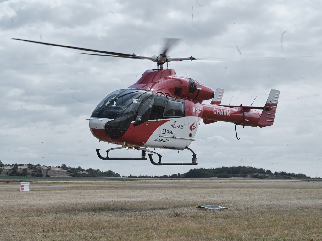
Airborne methane leak detection uses laser-based remote sensing technology mounted on a helicopter to scan the pipeline corridor from above. The core principle relies on the fact that methane absorbs light at specific wavelengths. By emitting two laser pulses at slightly different wavelengths and measuring the difference in reflected light, the system can calculate whether methane is present in the air column below the aircraft, and in what concentration.
This approach, known as Differential Absorption LIDAR (DIAL), allows the helicopter to cover large distances quickly without the need for ground crews to walk every meter of the route. The key performance parameters that determine whether a system can actually find real leaks in real conditions include:
- Scan swath width: The system must cover a wide enough corridor on both sides of the pipeline, not just a narrow line directly above it, to account for underground plume widening. Reliable detection requires coverage extending at least 10 meters on either side of the centerline.
- Spatial resolution: Each measurement point must be small enough to resolve a concentrated plume before dilution. A measurement spot diameter of 80 to 150 centimeters, combined with 1,000 measurements per second, provides the density needed to meet this requirement.
- Sensitivity headroom: A system verified to detect 300 ppm at the surface operates at three times the sensitivity required by the EU Methane Regulation Type-2 threshold of 1,000 ppm. That headroom is what guarantees reliable detection under all allowable wind and altitude conditions, not just ideal laboratory conditions.
- Georeferencing accuracy: Findings must be localized to better than 2 meters from the true leak location so ground crews can verify and repair efficiently.
Technology that produces only a string of measurement points along the pipeline centerline cannot reliably detect leaks where the plume has drifted laterally. A grid-based measurement approach is the physically correct solution to the underground plume widening problem.
How early can airborne surveys detect a gas leak?
The answer depends on two factors: the sensitivity of the detection system and how frequently surveys are conducted. A well-certified airborne system can detect leakage rates as low as 150 liters per hour under realistic operating conditions, including wind speeds up to 24 km/h. At that sensitivity level, leaks are identified at a very early stage, long before they would become visible through ground-level symptoms such as dead vegetation or pressure drops in the network.
Survey speed also plays a role in how early detection happens across a grid. A helicopter operating at up to 180 km/h can cover extensive pipeline networks in a single mobilization, meaning the entire grid is assessed within a defined window rather than through a prolonged rolling program. This matters because a leak that develops between infrequent inspections may go undetected for years under a less capable or less frequent program.
Once a potential leak is identified during a flight, the turnaround time to notification is remarkably short. When a spatially localized gas cloud with a particularly high concentration is detected in-flight, a prompt indication is flagged automatically. After landing, a data analyst verifies the finding and, if a plausible source is confirmed, the coordinates are forwarded to the client. In typical operations, this takes only one to two hours after the helicopter lands. Maintaining an open communication channel during weekend and off-hours operations is essential so that prompt indications are not delayed until the next working day.
What are the benefits of early CH4 detection for grid operators?
Early detection translates into concrete operational and financial advantages. The most immediate benefit is cost avoidance: a small leak repaired quickly is far less expensive than a large failure requiring emergency response, excavation, and infrastructure replacement. Beyond direct repair costs, early detection also reduces the volume of gas lost to the atmosphere, which has a direct impact on the operator’s commercial balance.
From a regulatory standpoint, operators using Type-2-certified technology gain access to the extended three-year inspection interval for underground pipelines under the EU Methane Regulation. This is not a minor administrative benefit. It means that the higher upfront investment in more sensitive airborne methane detection is partially recovered through reduced inspection frequency over the life of the program. A single-class framework fixed at a lower sensitivity threshold would remove this incentive entirely, which is precisely why the two-class Type-1/Type-2 structure is both technically sound and economically coherent with the regulation’s emission-reduction goals.
Early detection also supports OGMP 2.0 Level 5 reporting, which requires source-level emissions quantification. Operators who can demonstrate rigorous, high-sensitivity survey programs are better positioned to meet their reporting obligations with confidence rather than estimates. Survey results delivered through a secure Web GIS platform, accessible on both desktop and mobile devices, allow grid operators to verify findings and prioritize repair work efficiently without delays caused by cumbersome data transfer processes.
When should gas grid operators schedule methane leak surveys?
The EU Methane Regulation sets the outer boundary: underground pipelines inspected under a Type-2 program must be surveyed at least once every three years. But regulatory compliance sets a floor, not an optimal strategy. Operators managing aging infrastructure, networks in areas with variable soil conditions, or systems that have undergone recent modification may benefit from more frequent coverage.
Practical scheduling should also account for seasonal factors. Survey operations are subject to aviation weather limits, and planning campaigns during periods of stable, low-wind conditions maximizes the proportion of the network that can be surveyed in a single mobilization. Coordinating survey scheduling with planned maintenance windows also allows ground verification teams to be deployed efficiently immediately after prompt indications are received.
For operators who have not yet established a structured aerial survey program, 2026 is a meaningful moment to act. The EU Methane Regulation’s reporting obligations are already in force, the Implementing Act that will set specific aerial detection thresholds is progressing through consultation, and operators who establish certified survey programs now will be better prepared to demonstrate compliance when those thresholds are codified. Waiting until the Implementing Act is finalized before selecting a technology risks being caught without a compliant program in place.
You can explore the full range of pipeline inspection and methane detection services available to gas grid operators to understand what a structured aerial survey program looks like in practice.
How ADLARES helps gas grid operators with early CH4 detection
We have been providing airborne methane detection services commercially since 2008, and to date we have inspected more than 250,000 kilometers of gas pipelines across Europe. Our CHARM technology is the world’s only DVGW-approved aerial gas remote detection system, certified under DVGW G465-4-5, and fully Type-2 compliant under EU Methane Regulation 2024/1787. Here is what working with us delivers in practice:
- Type-2 certified sensitivity: CHARM is independently verified to detect surface concentrations of 300 ppm in a 2×2 m² area, three times more sensitive than the 1,000 ppm Type-2 threshold, giving operators reliable detection under all allowable conditions.
- Grid-based coverage: Our adjustable 10 to 30 meter scan swath covers the full corridor on either side of the pipeline, not just the centerline, accounting for underground plume widening as demonstrated in METEC and Engler-Bunte Institute research.
- Fast turnaround: Prompt indications of suspected leaks are typically communicated to clients within one to two hours of landing, with coordinates verified by our data analysts before forwarding.
- Secure Web GIS delivery: Survey results are delivered through a secure Web GIS platform accessible on desktop and mobile, so your team can act on findings immediately.
- Extended inspection intervals: Type-2 compliance means underground pipelines can be inspected once every three years, directly offsetting the cost of more sensitive technology.
- Regulatory readiness: Our certification satisfies Article 14(7)’s „best available technology“ requirement today, and positions operators well for the forthcoming Implementing Act thresholds.
If you manage a gas grid and want to understand how an aerial survey program can be structured around your network, we would be glad to discuss your specific situation. Visit our ADLARES website to learn more about our technology and approach, or get in touch with our team to start planning your next survey campaign.
Dieser Inhalt wurde mithilfe von KI erstellt und kann Fehler enthalten.